
Using GIS to assess hazard and vulnerability in urban areas: the city of Arequipa case study
March 19, 2018
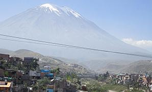
Arequipa is the second largest city in Peru with about 1 million inhabitants. Located about 15 km from the active volcano Misti and facing an uncontrolled urbanization, this city regularly faces with flash floods and lahars (volcanic mud flow).
The workshop was organized by the Clermont-Auvergne University (Laboratoire Magma et Volcans), the Technological University of Peru, the Instituto Geológico Minero y Metalúrgico, the University of Nariño (Colombia) and Instituto Géofísica-UNAM Mexico), in the presence of the Civil Defense and the Provincial Municipality of Arequipa. It aimed to pass on methodologies to students and policy makers about how to map hazards, exposure and vulnerability in a large city like Arequipa.
The presentations focused on the mapping hazard with simulation software (TITAN 2F, Volcworks, etc.), estimating the probability of damage using logistic regression, and studying the vulnerability of buildings with Engineering tools. Olivier Santoni, a geomatician at Ferdi, presented how, with GIS tools, it was possible to map the vulnerability of a large city. His speech focused in particular on the socio-economic vulnerability of the population to natural hazards. He presented an analysis on the type of dwellings and their remotness from the relief infrastructures. [See his presentation]
The presentations were supplemented by field visits to locate the valleys where the most exposed buildings, often also fragile, are constructed.
Book : Hazard and risk mapping : The Arequipa–El Misti case study and other threatened cities